How to read the labels.DOCUMENTED an original or contemporary record ·
SUPPORTED a credible published source or sourced tree; original not yet seen · FAMILY TRADITION a handed-down story, not yet proven ·
HYPOTHESIS a reasoned idea still to be tested · DISPROVEN-CORRECTED shown to be wrong, with the correction.
“Potts” means Thomas Maxwell Potts, Bi-Centenary Memorial of Jeremiah Carter (1883); “Court Record” means Record of the Courts of Chester County (1910).
Carter land in Chester Township, 1687–1931
Date
Event
Acres
Label
Source
by Dec 1687
A road is laid across “Jeremy Carters land”
—
DOCUMENTED
Court Record p.117
9 10mo 1690
Bought from William Woodmansee for £6 6s
20
DOCUMENTED
Court Record p.227; Potts p.27
11 Sep 1694
Robert and Lydia Wade give land to Jeremiah’s daughter Lydia
50
DOCUMENTED
Court Record p.331
1702–03
Bought from Henry and Mary Worley (180 acres), resurveyed as 215
215
SUPPORTED
Potts p.28
1703
Resurvey: total holding in Chester Township
285
SUPPORTED
Potts pp.28–29
1715–22
250 acres in Sadsbury Township, given to son Edward, then sold
250
SUPPORTED
Potts pp.30–31
Nov 1731
Conveyed to son Nineveh
−88
SUPPORTED
Potts p.31
1735/7
Will: home plantation to Mary, then Abraham
—
SUPPORTED
Potts pp.31–32
1777
Edward (d. 1777) leaves his Chester Creek land to Abraham
—
SUPPORTED
Potts p.48
1789–93
Abraham’s land divided: Joseph and Daniel about 165½, Edward 92, meadow about 8
≈265
SUPPORTED
Potts pp.48, 60–64
1819–21
Edward’s plantation, “fifty acres more or less”, to his daughter Ann Roberts
≈50
SUPPORTED
Potts pp.62–63
1872–79
Edward Carter the potter’s will and his son Paul B. Carter’s lawsuits
—
DOCUMENTED
Delaware County Daily Times, 13 Jun 1877; 15 Apr 1879
1931
Carter heirs still on record for a lot beside the burial ground
0.57
DOCUMENTED
Chester Times, 12 Feb 1931
285 or 440 acres?
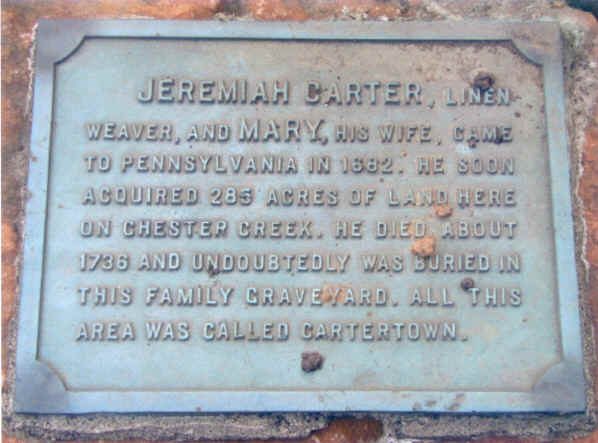
The records show 285 acres in Chester Township SUPPORTED.
The family figure of 440 acres is a rounded memory FAMILY TRADITION with no source yet. One possible origin is the “Lawrence Routh 436 acres” tract printed beside the Carter land on the 1703 plat HYPOTHESIS.
Maps and views
Photograph to come1703 resurvey plat (Potts p.29)From the Timothy family collection
Photograph to come1870 or 1875 Delaware County atlas: CartervilleFrom the Timothy family collection
Photograph to comeModern parcel map of the old Carter tractFrom the Timothy family collection
Photograph to comeChester Creek and the Carterville area todayFrom the Timothy family collection
The plaque at the Carter Graveyard. Photo: Kevin Timothy family collection.
An overlay of the old tracts on a modern parcel map is in preparation.