1777: The British in Aston
Two days after the Battle of Brandywine (11 September 1777), Lord Cornwallis brought the light infantry and grenadiers down through Concord to Aston. Captain John Montresor, the army's chief engineer, wrote that they reached “Ashton within 4 miles of Chester”. DOCUMENTED They camped about two nights within a mile or two of the Carter land on Chester Creek, then marched north to Goshen, the ‘Battle of the Clouds’ and Paoli.
The march, Brandywine to Aston and on to Paoli
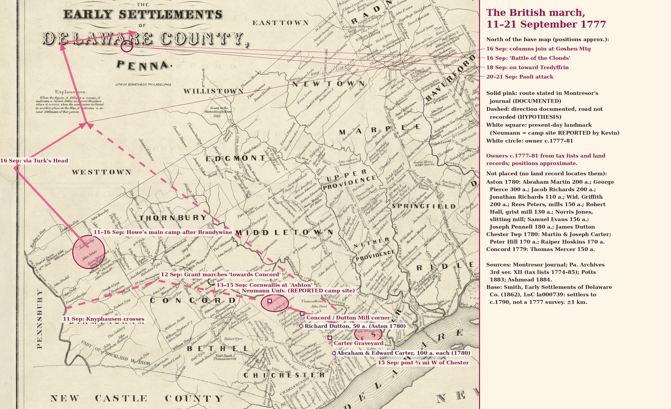
Who owned the land, 1777–81
No map of who owned the land in 1777 is known for Aston and Chester Township. The 1777 British and Hessian campaign maps (Montresor, Faden 1778, Wangenheim) and Scull & Heap's 1777 map show roads, streams and a few houses, not owners. The owners on the march map therefore come from records. They are taxables in the 1779–81 Chester County tax lists (Pennsylvania Archives, 3rd ser. vol. XII), the closest lists to 1777. A name is placed on the map only where a land record shows where that land lay. Everyone else is in the side list. SUPPORTED
| Owner (tax list) | Acres | Where placed | Label |
|---|---|---|---|
| Abraham Carter, Chester Twp (1779, 1780) | 100 | On the Jeremiah Carter tract by Chester Creek, at the Carter Graveyard (Potts 1883) | SUPPORTED |
| Edward Carter, Chester Twp (1779, 1780) | 100 | Same tract (Potts 1883) | SUPPORTED |
| Martin and Joseph Carter, Chester Twp (1779, 1780) | none listed | Not placed | DOCUMENTED |
| Richard Dutton, Aston (1780) | 50 | Near the Dutton Mill corner; approximate | HYPOTHESIS |
| Abraham Martin, Aston (1780) | 200 | Not placed. His link to Jonathan Martin of the 1777 story is unproven | HYPOTHESIS |
| George Pierce, Aston (1774 tavern; 1780) | 300 | Not placed | DOCUMENTED |
Day by day
| When | What happened | Label | Source |
|---|---|---|---|
| 11 Sep 1777 | Battle of Brandywine. Howe and Cornwallis flank the Americans at Birmingham. Knyphausen crosses at Chadds Ford. The British camp on the field near Dilworth. | DOCUMENTED | Montresor, Journals of Capt. John Montresor (Collections NYHS 1881 / PMHB), entries 12–21 Sep 1777 |
| 12 Sep, 2 p.m. | Maj. Gen. Grant marches the 1st and 2nd Brigades from Chadds Ford 'towards Concord', collecting wagons, cattle and hiding rebels. | DOCUMENTED | Montresor, Journals of Capt. John Montresor (Collections NYHS 1881 / PMHB), entries 12–21 Sep 1777 |
| 13 Sep, 6:30 a.m.–5 p.m. | Lord Cornwallis, with the 2nd Light Infantry and 2 battalions of Grenadiers, joins Grant and moves 'towards Chester'. At 5 p.m. he reaches 'Ashton within 4 miles of Chester'. Neighbours come in for protection. | DOCUMENTED | Montresor, Journals of Capt. John Montresor (Collections NYHS 1881 / PMHB), entries 12–21 Sep 1777 |
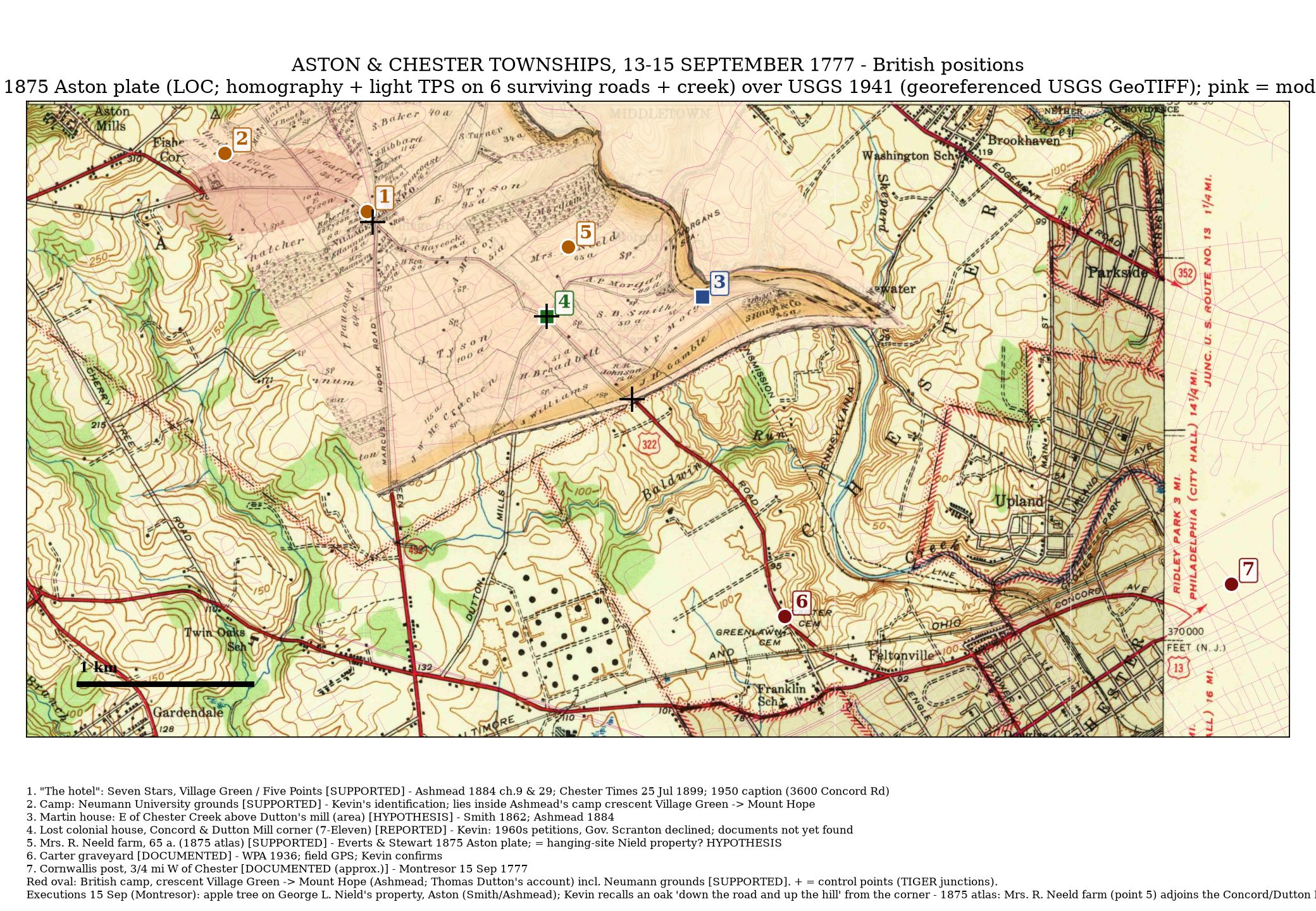
| 13–15 Sep | The camp stretches 'from Mount Hope to the lower part of Village Green'. Cornwallis lodges in an old brick house at Village Green. Foraging parties seize flour from the mills. | SUPPORTED | Ashmead, History of Delaware County (1884), p.291–292 |
| 13–15 Sep | Kevin places the camp on the ground where Neumann University now stands. That ground lies inside Ashmead's Mount Hope–Village Green camp. | REPORTED (Kevin) | Kevin, 30 Oct 2026 |
| 14 Sep, night | Three soldiers cross Chester Creek above Dutton's mill, plunder Jonathan Martin's house and slightly wound Mary Martin, 18, with a bayonet. They then rob Mr. Coxe's house near Sneath's Corner. | SUPPORTED | Ashmead, History of Delaware County (1884), p.291–292; Smith, History of Delaware County (1862), via Ashmead |
| 15 Sep | Howe rides with a dragoon escort to Cornwallis's post '¾ of a mile west of Chester'. Ashmead says this was 'in the neighborhood of the present Cartertown'. The girls identify the men and a court-martial follows. 'This day two men were executed, one Grenadier, and one light Infantry' (Montresor). | DOCUMENTED | Montresor, Journals of Capt. John Montresor (Collections NYHS 1881 / PMHB), entries 12–21 Sep 1777; Ashmead, History of Delaware County (1884), p.291–292 |
| 15 Sep | Smith says the two were hanged on an apple tree on George L. Nield's property in Aston. Kevin remembers a big oak 'down the road and up the hill'. The site is not located. | SUPPORTED | Smith, History of Delaware County (1862), via Ashmead |
| 15 Sep, 8 p.m. | Cornwallis's body 'moved from near Chester towards the Lancaster road'. The road taken is not recorded. | DOCUMENTED | Montresor, Journals of Capt. John Montresor (Collections NYHS 1881 / PMHB), entries 12–21 Sep 1777 |
| 16 Sep | The main army marches from Dilworth by the Turk's Head (West Chester) to Goshen Meeting and joins Cornwallis at 11 a.m. A gale and heavy rain cut short Wayne's attack (the 'Battle of the Clouds'). Headquarters: the Boot, Goshen. | DOCUMENTED | Montresor, Journals of Capt. John Montresor (Collections NYHS 1881 / PMHB), entries 12–21 Sep 1777 |
| 18 Sep | The army goes on by the White Horse to Tredyffrin. Stores are found at Valley Forge. | DOCUMENTED | Montresor, Journals of Capt. John Montresor (Collections NYHS 1881 / PMHB), entries 12–21 Sep 1777 |
| 20–21 Sep | Night attack on Wayne's camp near the Paoli tavern ('put … to the Bayonet'). On the 21st the army moves to Valley Forge and Moore Hall. | DOCUMENTED | Montresor, Journals of Capt. John Montresor (Collections NYHS 1881 / PMHB), entries 12–21 Sep 1777 |
The stay in Aston
Ashmead (1884) puts the camp in a crescent from Mount Hope to the lower part of Village Green. SUPPORTED Kevin's reported camp site is the Neumann University ground. REPORTED (Kevin) It lies inside that crescent. Neighbours came in for protection. Foragers took flour, which Cornwallis sent on to the main army on the 15th. DOCUMENTED
Local families
Mary Martin, 18, daughter of Jonathan Martin, was slightly wounded by a soldier's bayonet on the night of 14 September. Her testimony led to the court-martial and the two executions on the 15th. SUPPORTED (Ashmead 1884; Smith 1862). See the timeline. None of the soldiers or victims is known to be a Carter. No Carter loss claim for 1777 has been found yet. HYPOTHESIS
Where the sources agree and differ
They agree on dates, the Aston camp, the robbery at the Martin house and the two executions.
| Point | Sources |
|---|---|
| Who the soldiers were | Smith (1862) says Hessians. Montresor's journal, the primary source, says 'one Grenadier, and one light Infantry', i.e. British. |
| Where Cornwallis slept | Ashmead (1884): an old brick house at lower Village Green. Chester Times, 25 Jul 1899: the Seven Stars. |
| Cornwallis's forward post | Montresor: ¾ mile west of Chester. Ashmead: 'in the neighborhood of the present Cartertown', which is about 2 miles west of the old borough. Either the post moved, or Ashmead stretched the distance. |
| Hanging tree | Smith: an apple tree on G. L. Nield's land, Aston. Kevin: a large oak down the road and up the hill. The 1875 atlas shows 'Mrs. R. Neeld, 65 a.' just NE of the Concord/Dutton Mill corner (HYPOTHESIS that this is the same farm). |
| Concordville hanging story | Smith and Ashmead place the hanging in Aston, not Concordville (DISPROVEN-CORRECTED). |
| The red line on Kevin's copy of the 1862 map | It runs Edgmont → Middletown → Nether Providence → Ridley → Darby. No source ties it to the British route. It is not used as a route. |
Sources
- Montresor, The Montresor Journals, ed. G. D. Scull (NYHS Collections 1881), 11–21 Sep 1777. Primary source.
- Ashmead, History of Delaware County (1884), pp.291–292.
- Smith, History of Delaware County (1862), with its map of early settlements (Library of Congress 2012593312).
- Chester Times, 25 Jul 1899 (Seven Stars).
- Kevin's family account (REPORTED).